Hello, This Is London Rising: 3D Printing Maps from LIDAR Data
aeracode.orgThat's really cool. Wish it was printed in colour :)
If LIDAR data isn't available, you can do pretty detailed 3D mapping with a regular camera and UAV, using photogrammetry/structure from motion. A Phantom or almost anything that flies with a reasonable camera will do. Of course the better camera you use, the better the results. Flight restrictions over populated areas apply, check your local legislation :)
commercial solutions: https://pix4d.com/, http://www.agisoft.com/, http://www.dronedeploy.com
open source: https://github.com/OpenDroneMap/OpenDroneMap
Color 3D printing is pretty pricey still. For something of that scale you'd be looking at several thousand dollars, even breaking it down into small individual pieces.
Maybe it would be possible (for this concept) to just color the top layer using an overlay of data from OpenStreetMap or google maps. Probably would require a lot of tweaking to get the alignment right, but it would look fantastic.
I suppose no such ink/coloring-the-top-layer thing exists.
Using clever hollow boxes can bring the prices down significantly: http://www.shapeways.com/product/PCVV6V9G2/y-garn-relief
It's still pricey. Making it hollow only helps if it's tall. For color 3D printing, the material is gypsum powder (well, there is CMYK filament now, but I haven't looked into it much). You need considerably thicker walls, etc. Furthermore, the cost is as heavily influenced by machine space as by the amount of material used.
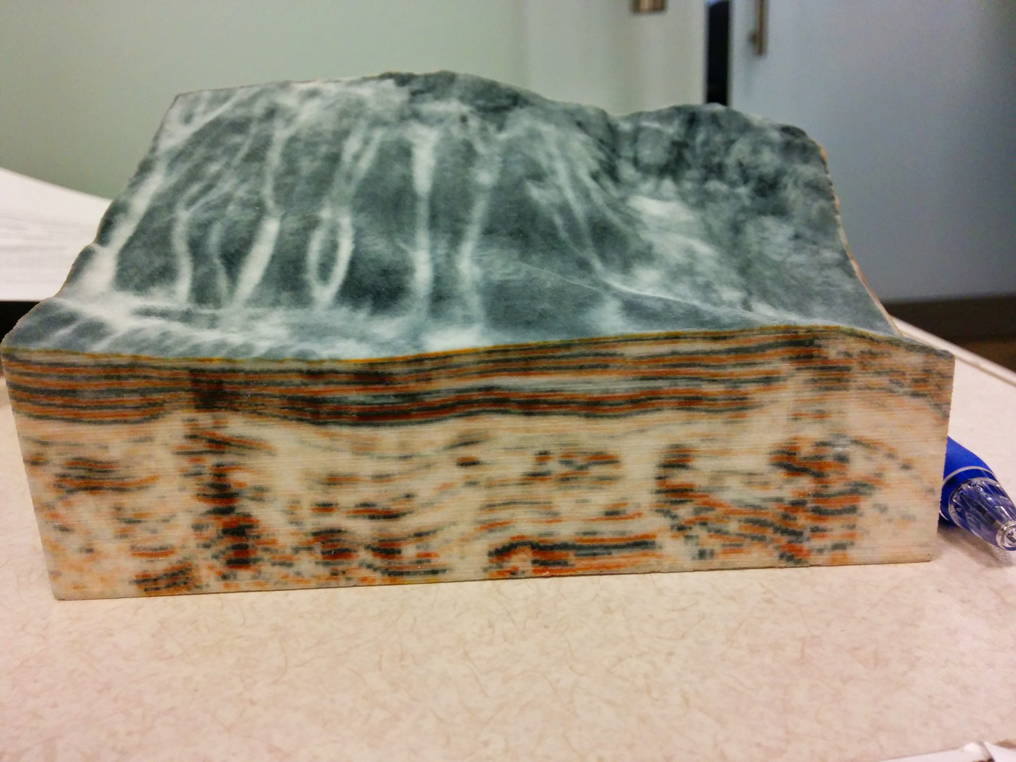
For example, this was ~$100. https://raw.githubusercontent.com/joferkington/scipy2015-3d_... I tried uploading and pricing a "hollow box" version, but it saved less than $5.
However, for this one, using a "hollow box" saved ~30%, (it's a comparable size, but much taller): https://raw.githubusercontent.com/joferkington/scipy2015-3d_...
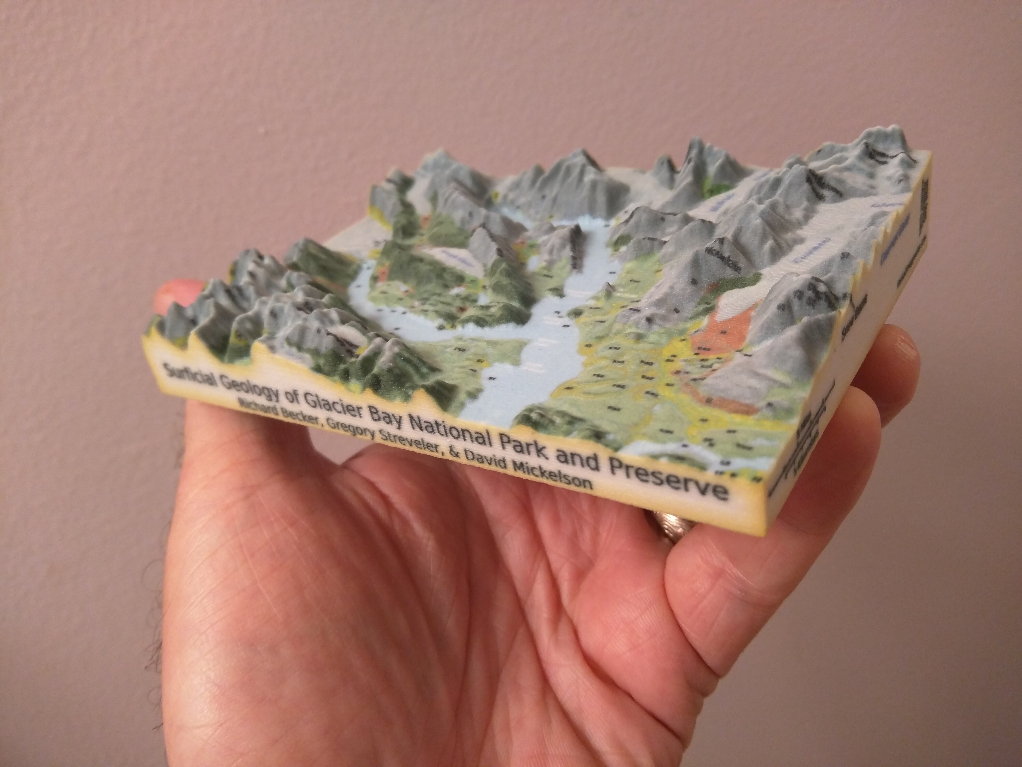
I just found and watched your SciPy talk. The 3d-printed geology puzzle is really cool!
Yeah, the British print is basically the bottomless box you show at 15:16, but with much thinner walls - I don't have it anymore but I'd say theirs are about .3 millimeter thick. I suppose that's also why you paid three times more.
Since they don't have a bottom lid, they apply their bottom texture underneath the top.
How difficult do you think it would be to clip the print along a border, e.g. the border of Alaska?
Thanks!
I erred on the side of too thick walls instead of too thin, as I was a bit worried about durability. They're thicker than they need to be, though. It would definitely drop costs to make them thinner.
As far as clipping along an arbitrary border, it shouldn't be difficult. I haven't actually made a model with a non-square border yet, but I've been meaning to for awhile. I probably won't have time to in the next few months, though. If you give it a try, let me know how it goes!
You could shine a laser projector on it to color it!
It's good to see LIDAR in the news! I work at Advanced Scientific Concepts (FPGA engineer), our flash LIDAR is 128x128, works out to several kilometers, and will be on the OSIRIS-Rex project to scoop some stuff up from an asteroid and return it to Earth - it's pretty wild.
We are developing a system for topology mapping like this specifically.
Check the mission out: http://www.asteroidmission.org/ and the company! http://www.advancedscientificconcepts.com/
If anybody is interested, send me a message.
Really cool. From the description it sounds like you just made one for yourself. I would suggest you try selling these for $500 - $2000 each. You put a lot of work into it and I think that as art these would be command some money in the market.
Printing it in a stereo lithography machine (think FormLABS) would get you the details you wanted. That said, from the photo it looks very nice on the wall.
NYC performed a LIDAR scan of NYC in conjunction with CUNY a few years ago so that they could build a 'solar map' to help estimate how much solar capacity could be installed on a building. Anyone know where to grab the LIDAR scan data from?
If you can't find it, you may be able to file a FOIA request for it.
Really great write up, with lots of clear details of every aspect.
I always lament that STL was the format 3D printing software ended up with (essentially a bag of triangles, usually in text format). Far better if slicers could take a true mesh, and not have to guess if coincident points on separate triangles actually amount to the same vertex, except of course for places where it doesn't!
You can collect LIDAR data for your own favorite part of city by using this $250 device and a cheap drone like 3DR Solo:
http://www.lightware.co.za/shop/en/drone-altimeters/51-sf11c...
The main issue you will face is permission to fly drone at 100m or so. In US there are way too many laws to do this.
It looks like aircraft was flying at 200m for above data. London's tallest structure are at 300m+ so this is not doable in all areas.
Also note that software like pix4d and AutoDesk 360 can construct 3D models purely from drone images or videos. I'm not sure how much better LIDAR models are compared to models from structure from motion.
That is a really nice project. Having lived in London, and having a 3D printer I am very tempted.
Nice.
An interesting map is an exaggerated-relief map of Europe as far east as Moscow, with marks for all known battles. Over the centuries, they were mostly in the same places. It gives you a sense of how geography affects politics.
How about printing a landscape from a map/contour lines? Do you think it is possible for example from OSM data? (That London looks totally cool.)
OSM is just vectors, there aren't a lot of limits on what the data can be used for.
This was recently posted to /r/openstreetmap:
I really don't have a sense of how useful such a map would be, but it's exactly a 3d extrusion of OSM data.
This is very interesting!
I don't really have anyone close that is visually impaired but this would be super cool to have at 3D printing events and such. Very neat idea.
It's not exactly contour lines, but I made a site [0] that creates STL files from a global digital elevation model. You can select a region of the Earth and get a 3D printable file of its terrain. Might be close to what you're looking for!
In college my group used topo maps and a laser cutter to construct a map of Colorado. The burned edges had a really nice effect http://www.instructables.com/id/TwitMap-Topographical-Colora...
I'll plug an open source lib I wrote called shp2stl that converts shapefiles into 3D models suitable for printing.
http://dougmccune.com/blog/2014/12/30/using-shp2stl-to-conve...
As long as you can convert the data into a height field it's possible. I reckon you could do contours with interpolation.
Any idea how high airplane was flying and what LIDAR device it was using?
I followed few links and ended up here but not sure if this is the one they used to collect data: http://geosurveysolutions.com/rapid-surveyor
Very interesting project and glad to see the documentation and results! Had me thinking this might be a fun long-term art project, where a city like this could be given color details by hand using various inks and/or paints. Just a thought inspired by the clever undertaking seen here.
Really awesome project @andrewgodwin! I'd love to do something like this for Pittsburgh as well!
What are the available data sets for Pgh?
That's a good question. Not sure!
Best I could find right now: Lidar point cloud data
http://www.dcnr.state.pa.us/topogeo/pamap/lidar/index.htm#cl...
Looks like Allegheny county was done in 2006.
What is nice about the point cloud data is that they classified each point as ground, road, water, etc
That is very cool! Have you thought about tiling along road /river edges to hide the seams?
One thing the author doesn't mention on 3D printing issues, is extruder retraction settings (essentially pulling back the filament from the hot end slightly before the head moves to a new path, thus limiting strings of fine filament between them)
Cool.
There was some discussion of the LIDAR data-set when it was released: https://news.ycombinator.com/item?id=10379279
Awesome, is there any data like this for SF / bay area?
Yes, from the SF city open data portal:
https://data.sfgov.org/Geographic-Locations-and-Boundaries/B...?
We're working on importing this data into OpenStreetMap:
https://wiki.openstreetmap.org/wiki/San_Francisco_Building_H...
There is, actually - the US has a (slightly worse) government data repository, but there's several LIDAR sets of the Bay Area, mostly from coastal surveys.
Does anyone know where to get Lidar or other 3D Data from Germany? (Especially Frankfurt?)
One of the best uses I've seen for a 3d printer so far!
Hey, I can see my (old) house from here!