Great Britain transport data API
Every stop, every timetable, one API key.
Bus, tram and rail across England, Scotland and Wales. Live train times from National Rail, live buses linked to their exact trip, disruptions matched to your route, and timetables refreshed every morning. All official open data, served as plain JSON.
Free tier, no card. 1,000 requests a day.
GET /v1/bus/vehicles.json?lat=53.4794&lon=-2.2453
{
  "line": "197",
  "operator": "Bee Network",
  "destination": "Chorlton Street Coach Station",
  "latitude": 53.476608,
  "longitude": -2.241816,
  "delay_seconds": -104
}387,881stops
631bus operators
1,541,858timetabled journeys
59,372,797timetabled calls
2,653rail stations
Answers a timetable can't give
Built from every bus TransCAPI tracks and every departure in the timetable, not just the next one.
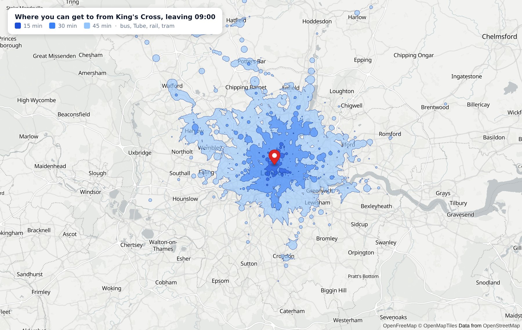
Reachability
Where can I get to in 30 minutes?
The area reachable by public transport from any point in Great Britain, as GeoJSON ready for a map, or the travel time from one place to up to 500 others in a single request. For property search, recruitment, site selection, or "which venue is easiest for everyone?"
Punctuality
How reliable is this bus, really?
Measured, not timetabled: on time, late and very late by route, by stop and by hour, from every tracked bus passing every timing point, on the Traffic Commissioners' definition of on time.
First's 51 in Sheffield, last 28 days
68%on time
90%on time leaving the first stop
51%on time at the last stop
1 in 10more than 8 min late at Church Street
From 136,782 observed stop calls. Worst at 17:00, 56% on time. Live from /v1/bus/reliability.json.
Connections
Will I make my change?
Every journey with a change says how often that change has actually worked for those exact buses over recent weeks. A 2-minute change that looks fine on paper and works one day in four is worth knowing about before you're stood at the stop.
# Sheffield station to Crookes, 08:00
GET /v1/journey.json?from_lat=53.378&from_lon=-1.462
                    &to_lat=53.386&to_lon=-1.513

"connection_chance_pct": 25,
"connections": [
  {
    "at": "West Street/Carver Street",
    "from_line": "120",
    "to_line": "52",
    "spare_s": 120,
    "chance_pct": 25,
    "basis": "trip_history",
    "days": 20
  }
]
Push alerts
Don't poll. We'll tell you.
Register a URL once and TransCAPI posts to it when your bus is a few minutes away, or when a disruption hits your stop, station, operator or route. Signed, retried if your server's down, and included on every plan. No more asking every minute whether anything has changed.
# What your server receives
POST /hooks/transcapi
X-TransCAPI-Event: vehicle_approaching
X-TransCAPI-Signature: sha256=bd2b3189aef3...

{
  "type": "vehicle_approaching",
  "data": {
    "atcocode": "370022870",
    "line": "95",
    "destination": "Walkley",
    "minutes_away": 9.5,
    "delay_seconds": 0,
    "vehicle": {
      "latitude": 53.381833,
      "longitude": -1.464979
    }
  }
}
One API across the whole network
Thirteen official feeds in eight formats, matched to each other and kept up to date as they change, so you don't have to.
Stops & places
Search every bus, tram and rail stop in Great Britain by point, radius or bounding box. Each one says which way its buses go, so two stops sharing a name are still tellable apart.
Departures & arrivals
Live rail times from National Rail's Darwin, with platforms, cancellations and delay reasons. Bus times across Great Britain, with live positions where an operator reports them. Arrival boards too — a terminus is a place people get off, not just a place nothing leaves.
Routes & geometry
A line's directions, calling points and the day's timetable — plus the path each direction actually takes, as an encoded polyline. Draw the road, not a line between stops.
Journey planning
Multi-modal itineraries with walking limits, turn-by-turn directions and fare estimates. Door to door, anywhere in Great Britain.
Disruptions
Planned works, incidents and line status for bus, tram, National Rail and the London network, in one shape. Pass a journey's path and get back only what touches that route, not every 21 in the country.
Open data, attributed
Every source and licence is listed, with the attribution line your users need to see. You can build on it commercially, knowing where it all comes from.
Push alerts
Webhooks when a bus is minutes from your stop or a disruption matches your filters. Signed JSON, retried if your server is down, so your app can stop polling.
Punctuality & reachability
How often each bus is really on time, the chance of making a change, and everywhere reachable in 30 minutes, measured from the buses themselves and the full timetable.
Carbon & climb
Every journey says its CO2 on the government's own factors, beside driving it alone, and how much uphill walking it involves, with a limit for gentle routes.
Built for the details that break transport apps
Getting the data is the easy part. These are the parts that take months to get right.
Disruptions that know your route
Pass a journey's path and get back only the roadworks, incidents and line closures that touch it. Service numbers aren't unique: First South Yorkshire runs a 21 in Barnsley and another in Rotherham, so filtering by line alone warns people about the wrong town.
/v1/disruptions.json?path=…&path_radius=300
Live means live, and says so
Rail comes from National Rail's own real-time system, with platforms, cancellations and the reason a train is late. Buses are linked to their exact timetabled trip, not guessed from a line number. Every departure says whether its time is live or timetabled, so you never show a guess as fact.
"source": "darwin"
Fresh every morning
Operators republish their timetables constantly, some every night, and each time the journey ids change. A timetable a few weeks old quietly stops matching the buses on the road. Ours is reloaded from the national export daily, with no downtime.
refreshed daily, 05:30
Roads, not straight lines
Routes come with the path each direction actually takes. Where an
operator publishes no geometry you get null, never a
line joining the stops, which runs through buildings and down roads
no bus can use.
"encoded_polyline": "qutdI|fkGG…"
Stops that say which way
A third of stops share a name with another, usually the pole across the road. Every stop says where its buses are heading, derived from the journeys that call there, which a passenger can act on and "adj" is not.
"towards": "Walkley"
Answers that admit what they don't know
Outside journey planning's coverage you get a clear
422 outside_coverage, not an empty list that reads as
"no buses". If a live feed is down the board still comes back,
timetabled, with the reason. Unknown delays are null,
not zero.
"live_error": null
Safe to build a business on
Every source is official open data, licensed for commercial use and listed with its licence. You get the exact attribution line your app needs to show, so there's nothing to untangle when you launch.
Room to grow before you pay
1,000 requests a day free, with every endpoint and every live feed. Paid tiers start at 50,000 a day, and every response tells you where you stand in its headers.
Ask a stop what is coming
One request, an API key in a header, JSON back. No SOAP envelope, no per-operator feed to reconcile, no GTFS zip to unpack at three in the morning.
- Plain REST and JSON, documented with live examples
- One key for bus, rail, journeys and disruptions
- Every source and licence listed, with the attribution line to copy
- Rate limits that tell you where you stand in the headers
$ curl -H "X-Api-Key: $KEY" \
    "https://api.transcapi.com/v1/bus/stops.json\
?lat=53.3824&lon=-1.4695&radius=100&limit=1"

{
  "member": [
    {
      "atcocode": "370022870",
      "name": "Church Street/High Street",
      "indicator": "HS5",
      "bearing": "W",
      "towards": "Walkley",
      "locality": "Sheffield Centre",
      "latitude": 53.382424,
      "longitude": -1.46953,
      "distance": 3.3
    }
  ]
}
All of Great Britain, and we show our working
That is not an illustration. Every mark is a stop in the register — 387,881 of them — plotted from the same table the API answers from. Great Britain draws itself.
Where coverage is thinner, the docs say so rather than letting you find out. Route geometry exists for the operators that publish it. Northern Ireland isn't covered: its network is published separately, outside the national feeds.
Build something with it
Free key, every endpoint, no card. Upgrade when your traffic says so.