
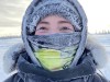
Gregor Luetzenburg is a PhD fellow in the Department of Geosciences and Natural Resource Management at the University of Copenhagen. Credit: Kent Pørksen
I know in this photo I look like I’m moonlighting as an Instagram model, but I’m actually doing some important, practical science that would have been impossible a couple of years ago.
Access options
Access Nature and 54 other Nature Portfolio journals
Get Nature+, our best-value online-access subscription
$32.99 / 30 days
cancel any time
Subscribe to this journal
Receive 52 print issues and online access
$199.00 per year
only $3.83 per issue
Rent or buy this article
Prices vary by article type
from$1.95
to$39.95
Prices may be subject to local taxes which are calculated during checkout
Nature 604, 794 (2022)
doi: https://doi.org/10.1038/d41586-022-01118-y
Related Articles
-
 How local communities helped polar scientists during the pandemic
-
 No PhDs needed: how citizen science is transforming research
 Protector of giant salamander
Subjects
Latest on:


Jobs
-
-
-
Associate or Senior Editor, Discover Journals
Job Title: Associate or Senior Editor, Discover Journals Location: Nanjing, Shanghai, Beijing or Pune, Hybrid Working Model Application Deadl...
Nanjing, Shanghai, Beijing or Pune, Hybrid Working Model
Springer Nature Ltd
-
PhD candidate (f/m/d)
We invite applications for the Research Group Biofluorescence: PhD candidate (f/m/d)
Dortmund, Nordrhein-Westfalen (DE)
Leibniz-Institut für Analytische Wissenschaften – ISAS – e.V.
-