Hi! At the beginning of the year, y’all told me some things you’d like to see in Uncharted Territories. At the top of the list was seeing Uncharted Territories articles as YouTube videos, so I’m taking a stab at it! Here’s the first one.
I’m just starting, so please let me know everything that works or doesn’t. I’m here to improve! Alright, let’s go to this week’s article, it’s on a fascinating topic!
The Mediterranean Sea didn't exist 6M years ago. It had dried up into a series of salty lakes. Then a megaflood filled it in a matter of months, killing everything in its path.
But it wasn’t just one megaflood. It was a series of floods.
Why did the Mediterranean dry up?
How do we know?
What happened then?
Why did it fill up so brutally fast?
What would it have been like to be there?
This is what we’re going to answer today1!
Let’s rewind. Hundreds of millions of years ago, there was an ocean between Eurasia and Africa, Tethys.
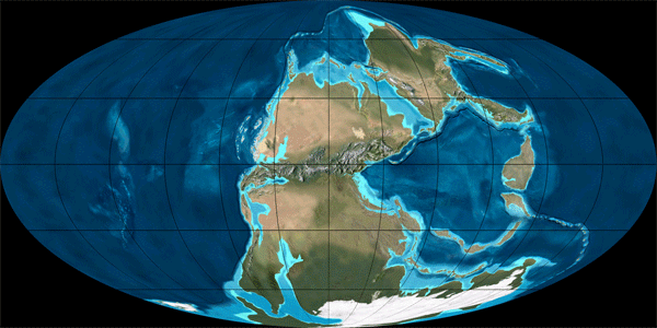
Over time, it evolved into the Indian Ocean and seas like the Mediterranean and the Red Sea, which appeared only a few tens of millions of years ago. Since then, the African and European tectonic plates have been colliding, forming the mountains of southern Europe over millions of years.

We can also see it in the bathymetry (underwater topography) of the Mediterranean. Can you see how the seafloor generally slopes gently downward from Africa towards Europe?
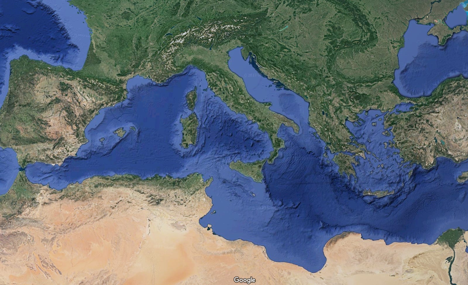
That’s because the African Plate is going slightly below the Eurasian Plate, forming a deeper sea where that subduction happens2.
We can see the complex tectonic plates of the Mediterranean here:

Logically, with all this pushing, it started closing.
First, water kept flowing from the Atlantic to the Mediterranean, through what’s today the Guadalquivir River Valley3.

Eventually, the path from Atlantic to Mediterranean completely closed.
As it did, evaporation quickly dried up the sea. It supposedly took only 1,000 years.
How do we know this happened? This is heavily debated today, but there are a couple of factors.
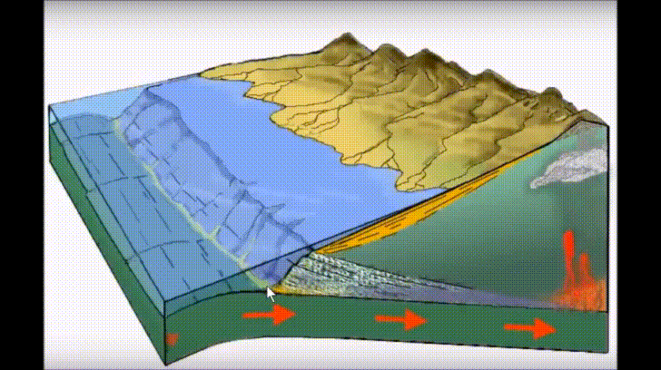
Look at the bottom of the Mediterranean Sea now. Can you see the riverbeds carved into the seabed? That only happens when water flows on ground above the sea.
Scientists believe most of these riverbeds were carved during the Messinian Salinity Crisis, when the water levels dropped by over 1 km. If you think about it, rivers can only carve their riverbeds thanks to gravity above the sea. Afterwards, it mixes with the seawater and can’t keep eroding the ground4.
Here’s a still:

This tells you the approximate levels of the remaining sea at the time: where the carving disappears.
There are other such canyons carved into the ground. The biggest one is, obviously, at the Strait of Gibraltar, formed during the Zanclean Flood.

The flood created a canyon 200 km long, 8 km wide, and hundreds of meters deep5.
Similarly, in rivers like the Rhône in France or the Nile in Egypt, the fact that sea waters dropped so drastically meant that the levels of the rivers also fell. They carved the ground much more aggressively, creating very deep canyons hundreds of meters deep6.
There’s another way we can tell: salt.
When so much water evaporates, its salt accumulates. This happens in the Dead Sea today—which is 1km deep7.

In an event like this, we should see a massive amount of salt in the deepest parts of the Mediterranean. We do!

Salt reaches a depth of over 1.5 km in the Mediterranean seafloor!

The salt mines are so big and deep that we could be mining them for thousands of years and never run out.

Today, we know that this layer trapped about 10% of the oceans' salt during the Messinian times!
And then 600,000 years later… BOOM!
If you didn’t click on the video above, you should click on it now!
Water furiously tore through the Strait of Gibraltar and started pouring in. Like 30,000 Niagara Falls gushing through. More than 100x all the water that rivers discharge into oceans worldwide.
We can see it in action in this experiment:
At first water trickles in.
It carries some sediment.
Which widens the gap.
More water flows in.
Carrying more sediment.
Opening a wider hole…
Soon, you have a megaflood.
Can you imagine what that felt like?

Imagine how it felt to the animals or hominids8 living there9. Your species has been here 400k years.
Suddenly, water appears.
You run away.
You try to escape.
But water keeps rising.
10m per day.
If you’re lucky, you live on a future island.
The rest drowned.
Massive extinction event.
But look at the middle of the Mediterranean, at the altitude of the seabed (again, bathymetry):

An underwater bridge exists between Africa, Malta, Sicily, and the Italian Boot. The seabed is elevated there. So initially only the West Mediterranean gathered water. As it poured in from the Atlantic, it filled in two weeks! Then…
Another flood!
How do we know? Because we have a good idea of where it happened.

Just at the mouth of the Noto Canyon, southeast of Sicily, there are massive amounts of deposits10 consistent with a brutal flood. Here, a huge waterfall formed, 1.5 km high, 50% higher than Angel Falls, the world’s tallest waterfall today11.
It took less than two years for water to fill the Mediterranean basin12.
And this is how the Zanclean Megaflood opened the Gibraltar Strait, flooded everything in what is today the Mediterranean, killed everything in its path, but created a new sea habitat—one that humans used 5M years later to thrive.
If you liked this post, share it with a friend. Over 20 million people read a shorter version of this on Twitter, so clearly this is something fascinates people! Who do you think that could be interested?
Most of the research and visualizations in this email were performed by Garcia-Castellanos & Manolo Mantero, @CSIC-Geo3BCN. They’ve done all the hard work here. You can follow García-Castellanos’s YouTube channel here and Twitter here.
If you enjoyed this, you might enjoy this one I did about something similar that happened just a few thousand years ago between the UK and France13.
Did a similar megaflood happen in the Black Sea?
Could it be the one mentioned in religious texts around the world?
What caused the opening in Gibraltar? Was it tectonic plates? Erosion? Something else?
Did this cause... volcanoes to erupt?
What other megafloods have there been?
What happened to the local fauna?
I’ll cover these in this week’s premium article!