In the last article, we started looking at rivers, understanding one of their most significant traits: They naturally move, and this can have serious consequences for humans and politics, to the point of getting presidents killed. Today, we’re going to go deeper to understand why rivers move, how humans have tried to wrangle them, and what the future of rivers holds.
Humans have spent thousands of years modifying rivers to get them to do our bidding. But what is “our bidding”? What goals do we have for rivers?
Give us water for irrigation
Provide natural fertilizer
Allow people and goods to travel cheaply, which allows for trade and wealth
Give us energy
Be crossable by infrastructure such as roads and railways
Stay in one place, so that we don’t need to be changing roads and houses and land ownership all the time
Be straight, so that we can travel faster and divide surrounding land neatly
Don’t flood the surroundings
Drain water efficiently when they swell
Be beautiful
Attract and nourish wildlife
Unfortunately, these goals are at odds. That’s how we ended up with rivers like this:
This is the brutalist version of rivers.

How did we end up here? What can we do about it? The key is to understand flooding:
We tend to think of rivers like this:
But if you radiograph rivers, you discover their true nature:
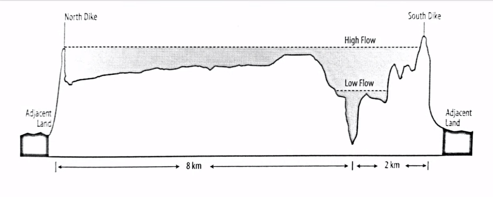
The first thing you’ll notice is the difference between the river and the floodplain:

These pictures are made with a new laser technique called LiDAR, but we’ve known about these floodplains for ages. We just couldn’t easily picture them. It took a lot of work. This is an example: the drawing of the floodplain of the Mississippi in the 1940s:

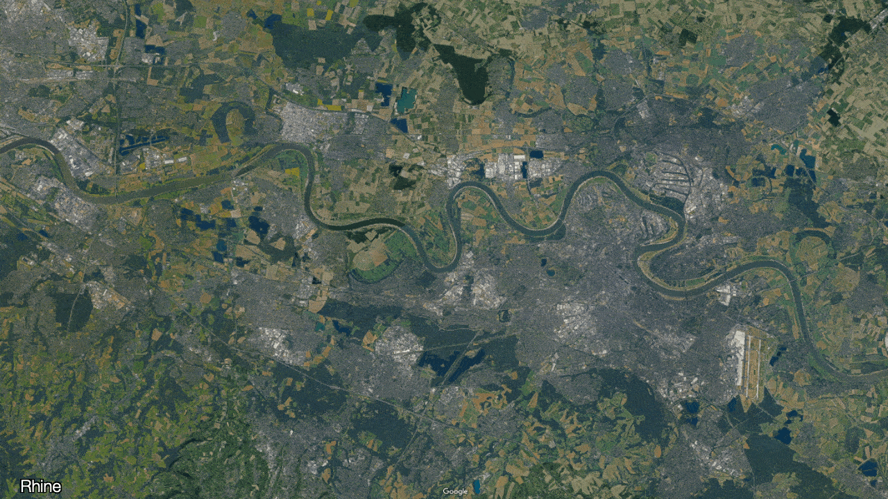
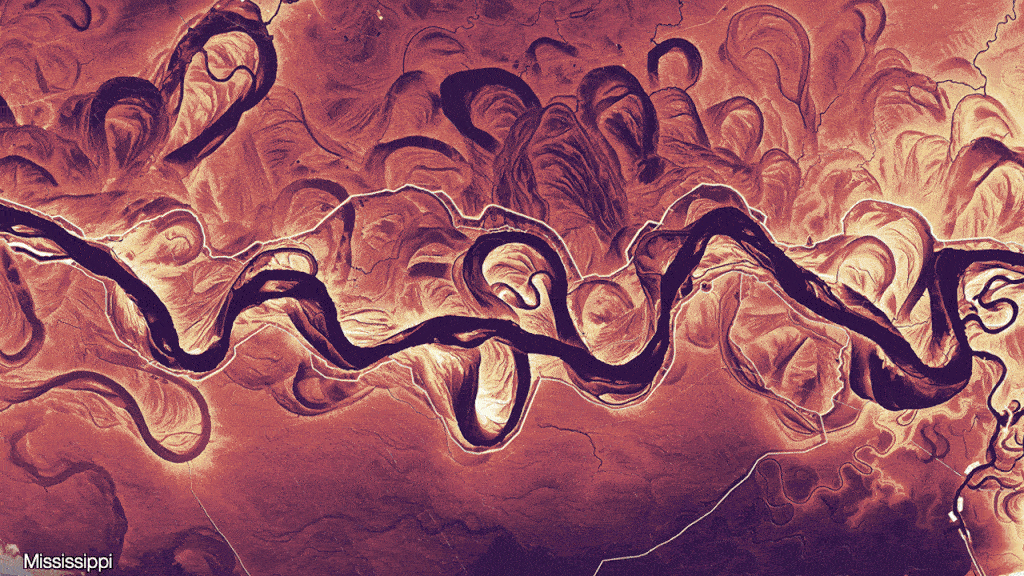
The river is but a small part of the floodplain! If you pay attention, you can see these floodplains on the satellite images:

Why does this happen? Because natural rivers move all the time:

You can see this in action in this real-life simulation from
Simulation from Emriver, via Practical Engineer
Why do rivers do this? The key is water speed vs sediment.
You might start with a river that is pretty straight, but in nature, nothing is mathematically straight. It will have a very slight bend. This bend means that on one side, water will move slightly faster than the other.

Water that is faster increases erosion, so the left side will eat away the riverbank. Water that is slower deposits sediments, so the right side will create a sandbank.

The more time passes, the more the left erodes and the right builds a sandbank. This pushes the water outward, creating less erosion on the inner (right) side and more on the outer (left) side. This creates a bigger and bigger meander:

At the same time, the water in the outer part of the river will accelerate and then smash against the other side of the riverbank, creating the next meander.
You can see both of these effects at play in this simulation:
This is how we get pictures like this one:


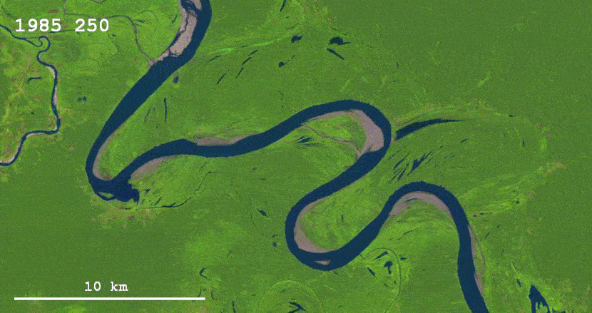
At some point, the meander is so curvy that it smashes into itself, cutting off the previous arm and forming an oxbow lake:
Some rivers form tons of them:

This is the type of course change that is least damaging to surrounding areas, as it happens within the floodplain—and in fact this type of behavior forms the floodplain, adding layers and layers of sediment that fertilize the soil. To give you a sense, over 100M Egyptians live on the floodplain of the Nile.
Although rivers change continually, the most significant changes happen during floods.
This is how much the course of China’s Yellow River has changed over history:
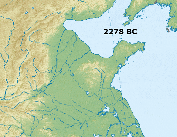
Here’s the change of its mouth in just 25 years, between 1979 and 2003:
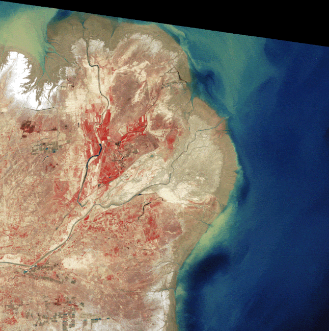
In the last 2500 years, the Yellow River has noticeably shifted its course 26 times, dramatically shifted nine times, and has flooded over 1,600 times. These floods are highly destructive and lethal. The worst floods killed people by the millions.
There are at least four reasons for this deadliness. One is that the land where the population resides is very flat:

It’s easier for floods to happen in flatland, where a river can easily shift its course, than in mountainous territory.
The second reason is that the Yellow River begins in mountains that load it with silt (hence “yellow”):
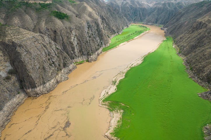
That silt accumulates as the river slows down in the plains, and it forms sand banks. As these banks grow, they can deviate the river’s waters.
This highlights the third reason why Yellow River floods have been so deadly: All rivers are naturally unstable because the silt they accumulate from the mountains raises the riverbed until it’s so high that the river finds another path. That’s what creates the floodplain. But sometimes the entire floodplain gets so silted that it’s elevated above the rest of the surrounding land. When that happens, rivers can leave their entire floodplains to follow a new path.
Finally, China has monsoons that can drop a lot of water in a short period of time. The other source of its river water is Tibet, where snowpacks melt during heat waves. These two factors can push a lot of water downriver at once, making the river change its course.
The risk of deadly flooding is why the first priority of river management has always been flood control.
Since floods and course changes happened frequently on the Yellow River, people built dikes on its banks. This limited the river’s natural meandering and flooding.
But this constraint on the river’s movement meant the only place it could deposit its silt was on the existing riverbed.

This silt accumulation raised the river over time. The more the riverbed rose, the more the dikes had to follow.

Today, the riverbed is 10 m (about 33 ft) above the surrounding plain.
What we have here is not a river, but an aqueduct.—James C. Scott.
Imagine what happens when rivers like this flood: They overflow the dikes, and since they’re so elevated, the entirety of their water exits the riverbed—and maybe even the floodplain.
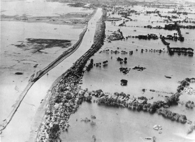
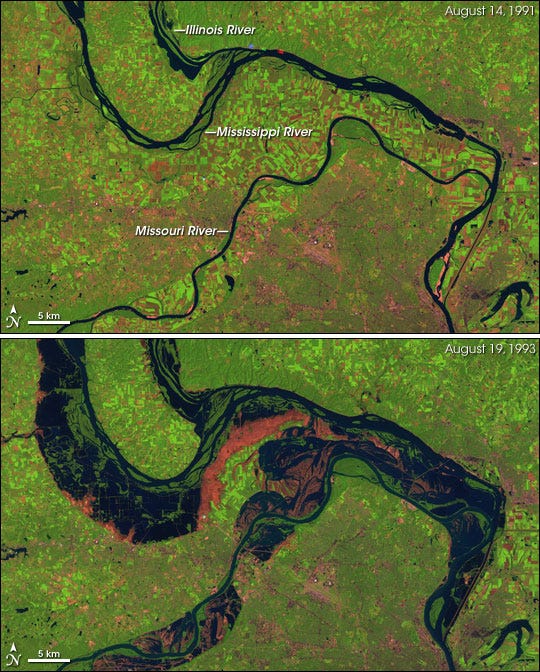
We got a small taste of that during the Mississippi River floods of 1993—although it stayed in the floodplains:

In places where a river has been constrained and the floodplain has been occupied by human activity, there is no buffer for this type of flood.
This is exacerbated in urban areas, where concrete prevents water from easily penetrating the soil, so it rushes downhill instead. As a result, we routinely see floods like these across the world:
Clearly, it’s not enough to constrain water in its riverbed: Flood waters can be too voluminous for dikes. Another solution was needed.
Another means of flood control is having the entire floodplain, rather than just the riverbank, carry water. This means reclaiming it for the river.
The Netherlands has been doing this for the river Meuse:

Another way to increase the water holding capacity of floodplains is with wetlands: With their vegetation and natural obstacles, they can buffer water more efficiently than simple floodplains.
Here’s a visualization of how vegetation stops floods:
The problem of course is that you drained your wetlands, you can’t recreate them where lots of people live, so it’s a limited solution.
What about agriculture? Historically, floods were useful to it as they brought fertile sediments. Today, however, we have artificial fertilizers, so the benefit of flooding is less. This limits the amount of floodplains we can use, and even more their transformation into wetlands. What other solution do we have to buffer the flow of water? Instead of horizontally, we can do it vertically.
These are all the dams on the Danube:
On its upper reaches, where the slope is steep, it has one dam every 6 km, on average! You can imagine how much buffer that provides: The more dams, the more the river can safely fill during floods and be used during droughts, providing a key control over the water.
Famously, the Nile stopped flooding downstream after the Aswan Dam was built. Today, the Nile has about 25 dams.
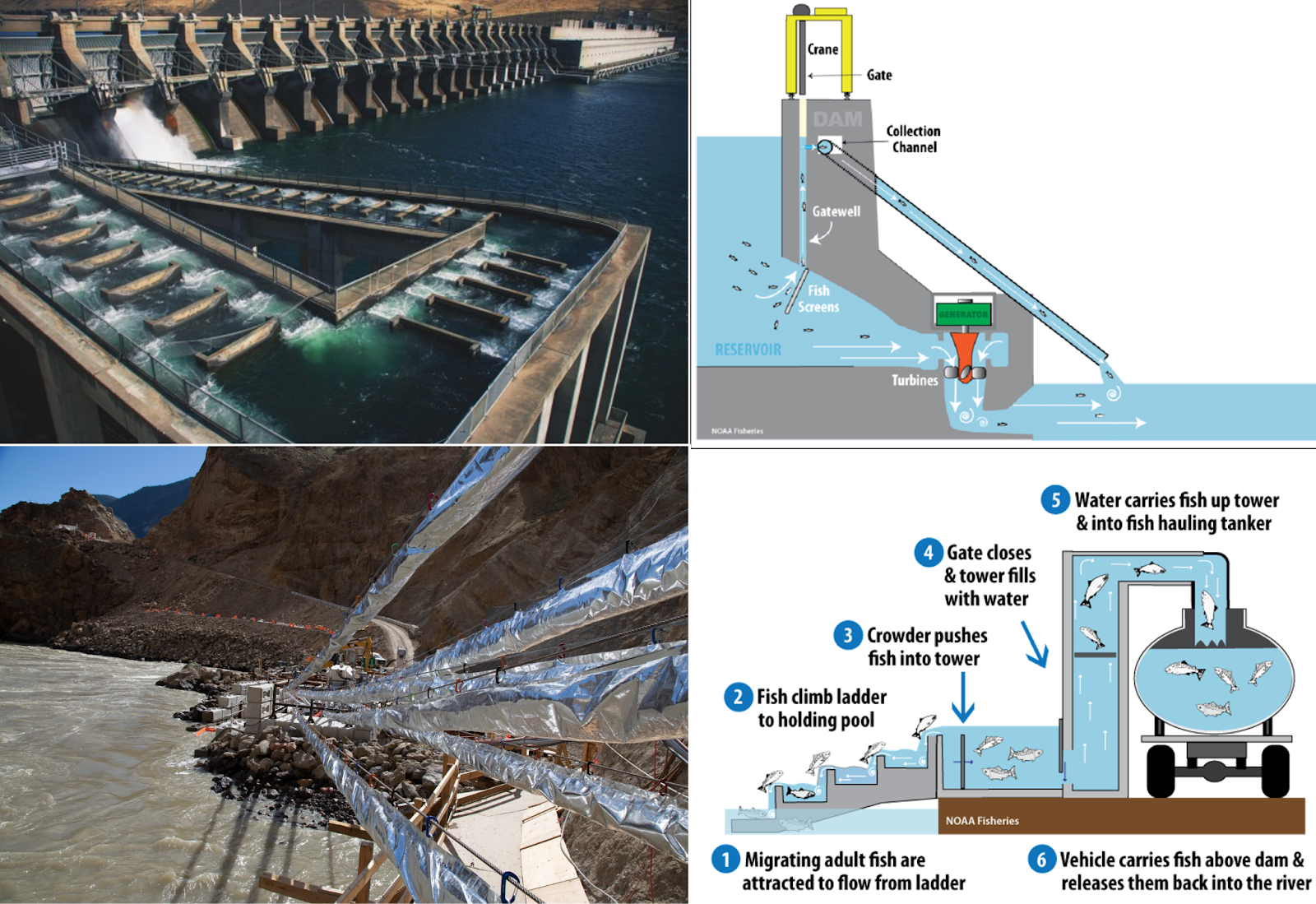
Dams double as a means to generate electricity, but they have their drawbacks: They don’t just stop the movement of water; they also stop everything else, including silt and fish. The solution for built-up silt is replace its downstream function with artificial fertilizer. The solution for blocking the fish is to bypass the dam:
Another solution to flooding is to constantly extract the new sediment deposits from the riverbed.

Embankments, floodplains, wetlands, dams, and dredging are the primary ways we manage flooding today. But freedom from flooding is not the only thing we want from rivers. One of their most important benefits is cheap transportation.
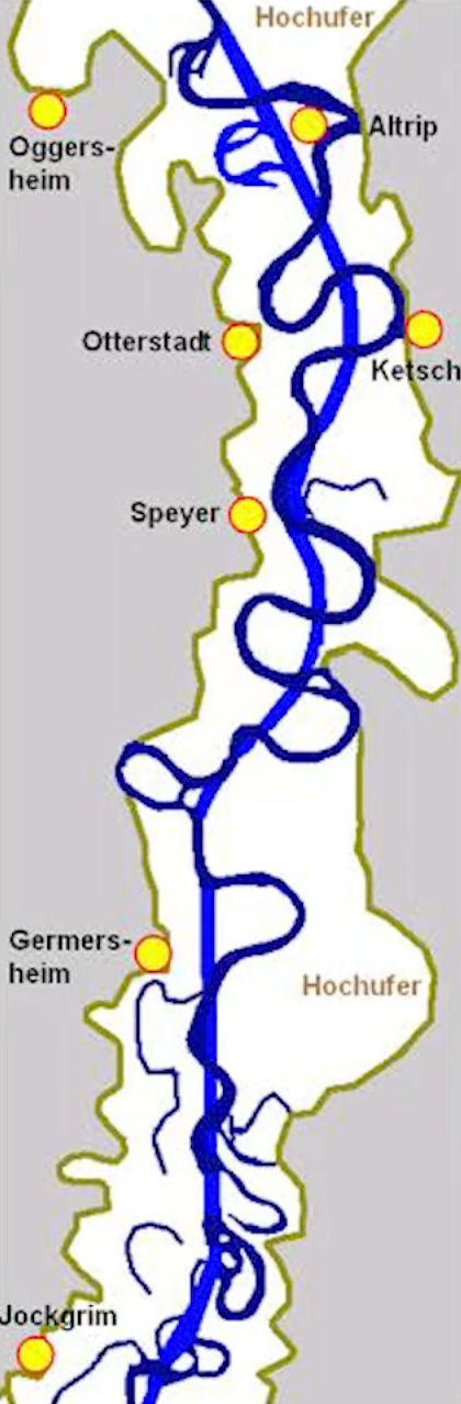
Around 100km of the Rhine river was straightened in the 19th century to reduce the odds that a flood would outflow a meander and to speed up transportation.1
Let’s assume this is its new profile:
A drop of water used to take 10 days to flow from Switzerland to the sea. After the Rhine was straightened, it only took 3 days. In the process, it lost 80% of its floodplain.
The shortening happened in the flatter area, let’s say starting at the Neckar. That means this section of the Rhine is about 600 km long, and used to be about 700 km long. The vertical drop in this section is 100 m. This means the river went from dropping 14 cm per km to 17 cm per km. That’s an increase in slope of 20%, which corresponds to an increase in water speed of about 10%. You know what happens when slopes are steeper and water moves faster, right? More erosion, more sediments, more sandbanks—treacherous for navigation and greater potential for the river to change course.
Normally, nature would erode and meander this increased speed away, lengthening the actual river until it slows down the water flow. But now the river is constrained to a straight line, so it can’t. The result is consistently faster waters, which means more erosion and constant accumulation of sediments—unless the river is also dammed.
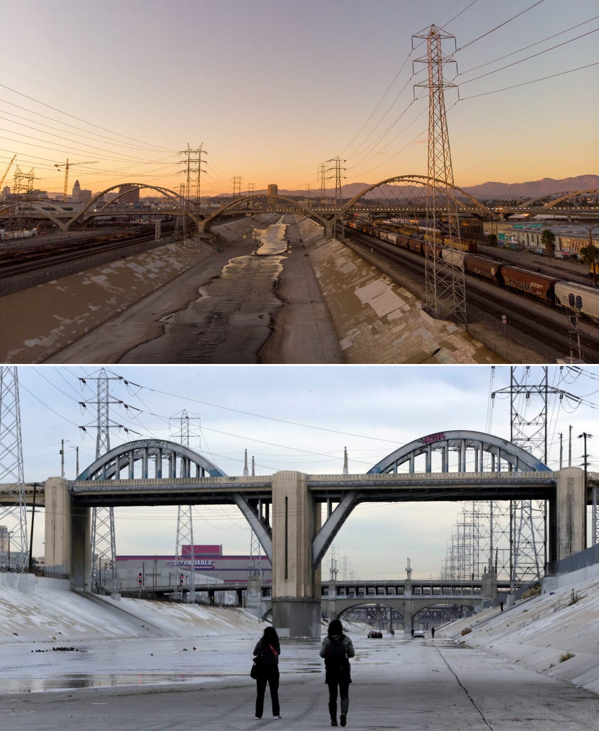
Fortunately, LA is exploring the revitalization of its river:
Other cities have already done it, like Madrid and its Rio area:
This reclaiming of floodplains and wetlands for recreation is ideal for small or highly seasonal rivers, for which the only concern is flood control.
If a country needs to use the floodplain for agriculture, it can’t afford to free that land.
If the river is needed for transportation, it must be as straight and deep as possible. This inevitably means concentrating water in its riverbed by building embankments. All this will inevitably accelerate the speed of water, which will increase erosion and bring silt, so river authorities will need to dredge the river. Since there’s a risk of floods, they can use floodplains and wetlands to stem overflow if they’re not in urban or agricultural areas. Even then, they usually need dams to act as buffers.
We are moving toward a greener world with more floodplains and wetlands instead of rivers of concrete. But we shouldn’t expect to rewild rivers completely: They use lots of land, risk floods, and are not easily navigable, so we must continue engineering them to serve us.