I want to find the least convenient location from the intersection of New Hampshire and 3rd street in Los Angeles within 20 miles or so.
All the inconvenience coefficients computed from this data look like this (source, data):
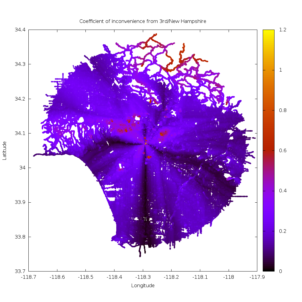
As expected, straight roads away from the starting point are highly efficient, and we see this in the Vermont corridor, 3rd street, and to a lesser extent 6th street going East. Also as expected, routes that do not align with the street grid are inefficient: we see inefficiency bumps going NW and SW from the starting point. Eastward from the start the street grid tilts, so things are more complicated in that direction.
We also see that hilly neighborhoods stand out: winding streets are not efficient. The Santa Monica mountains, Verdugos, Mount Washington and the San Gabriel Mountains clearly stand out. One can also make out the river paths in the bottom-right as ridges of inconvenience: their limited access nature makes it necessary to travel longer distance to get to them.
Onwards. The output of compute is sorted by road distance from the start. I
prepend the coefficient of inconvenience, re-sort the list and take 50 most
inconvenient locations by invoking
$ <query_34.0690448_-118.292924_20miles.out
   awk '$4 {printf "%f %f %f %f %f\n",($3-$4)/$4,$1,$2,$3,$4}' |
   sort -n -k1 -r | head -n 50
The output is this:
| Inconvenience | Latitude | Longitude | Road distance (m) | Direct distance (m) |
|---|---|---|---|---|
| 1.142052 | 34.068104 | -118.290382 | 549.216980 | 256.397583 |
| 1.139839 | 34.071629 | -118.288956 | 994.499390 | 464.754242 |
| 1.139147 | 34.068066 | -118.290436 | 542.721497 | 253.709305 |
| 1.136799 | 34.068130 | -118.290329 | 554.962891 | 259.716919 |
| 1.127631 | 34.068031 | -118.290466 | 537.980652 | 252.854279 |
| 1.120537 | 34.068153 | -118.290253 | 562.437012 | 265.233337 |
| 1.106771 | 34.067982 | -118.290504 | 531.442017 | 252.254257 |
| 1.103518 | 34.068169 | -118.290184 | 568.985352 | 270.492218 |
| 1.083344 | 34.067940 | -118.290527 | 526.321899 | 252.633179 |
| 1.079027 | 34.068176 | -118.290100 | 576.762024 | 277.419189 |
| 1.041816 | 34.067883 | -118.290543 | 519.805908 | 254.580200 |
| 1.034252 | 34.070259 | -118.291237 | 418.454498 | 205.704315 |
| 1.019096 | 34.071594 | -118.287888 | 1097.392212 | 543.506653 |
| 0.974731 | 34.068214 | -118.289680 | 617.407532 | 312.654022 |
| 0.970095 | 34.068176 | -118.289719 | 611.899475 | 310.593842 |
| 0.917598 | 34.068111 | -118.289383 | 656.267517 | 342.234131 |
| 0.910048 | 34.068165 | -118.289383 | 650.329041 | 340.477783 |
| 0.902491 | 34.068214 | -118.289383 | 644.814758 | 338.931915 |
| 0.770809 | 34.067570 | -118.290543 | 485.023560 | 273.899414 |
| 0.760711 | 34.068214 | -118.288643 | 712.981384 | 404.939484 |
| 0.753344 | 34.068214 | -118.288597 | 717.197876 | 409.045654 |
| 0.750541 | 34.033188 | -118.279716 | 7297.569824 | 4168.751465 |
| 0.747349 | 34.031826 | -118.279968 | 7526.415039 | 4307.333008 |
| 0.743357 | 34.067772 | -118.289474 | 606.347107 | 347.804382 |
| 0.741902 | 34.067787 | -118.289436 | 610.249084 | 350.334900 |
| 0.740024 | 34.067749 | -118.289505 | 602.555115 | 346.291290 |
| 0.739944 | 34.031769 | -118.279823 | 7511.619141 | 4317.161621 |
| 0.738388 | 34.031582 | -118.280746 | 7499.802734 | 4314.228516 |
| 0.737889 | 34.067795 | -118.289398 | 613.863831 | 353.223755 |
| 0.737716 | 34.031742 | -118.279800 | 7507.977051 | 4320.601562 |
| 0.736297 | 34.031372 | -118.280258 | 7550.486816 | 4348.613770 |
| 0.735083 | 34.068108 | -118.288734 | 693.459473 | 399.669403 |
| 0.734607 | 34.067730 | -118.289520 | 600.010803 | 345.905945 |
| 0.732851 | 34.031685 | -118.279747 | 7499.933105 | 4328.088379 |
| 0.730817 | 34.067795 | -118.289352 | 618.080322 | 357.103241 |
| 0.730543 | 34.031654 | -118.279732 | 7496.259766 | 4331.739746 |
| 0.728622 | 34.031628 | -118.279724 | 7493.208496 | 4334.787109 |
| 0.727123 | 34.067707 | -118.289536 | 597.103455 | 345.721344 |
| 0.726802 | 34.031601 | -118.279724 | 7490.239258 | 4337.637207 |
| 0.724309 | 34.031563 | -118.279739 | 7485.770508 | 4341.315430 |
| 0.723138 | 34.067791 | -118.289307 | 622.318115 | 361.153992 |
| 0.722826 | 34.031540 | -118.279755 | 7482.862793 | 4343.366211 |
| 0.722384 | 34.094849 | -118.236145 | 10273.032227 | 5964.425293 |
| 0.721979 | 34.094719 | -118.235779 | 10309.708008 | 5987.128906 |
| 0.721011 | 34.094639 | -118.235474 | 10339.187500 | 6007.625977 |
| 0.720812 | 34.094620 | -118.235405 | 10345.856445 | 6012.193359 |
| 0.720105 | 34.031498 | -118.279778 | 7477.742188 | 4347.258789 |
| 0.720078 | 34.094543 | -118.235138 | 10371.867188 | 6029.880859 |
| 0.719789 | 34.031509 | -118.279755 | 7475.278809 | 4346.624512 |
| 0.719616 | 34.095020 | -118.236320 | 10248.023438 | 5959.484863 |
There are 3 clusters of data. All the stuff < 500m away from the start is mostly degenerate and uninteresting (source):
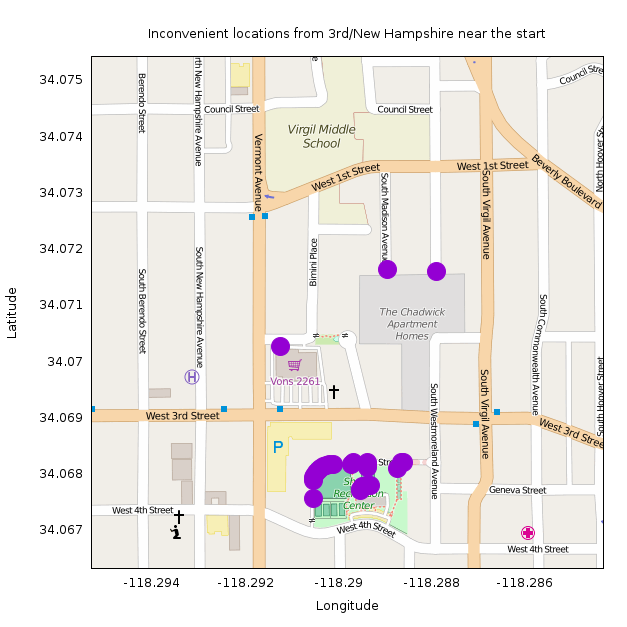
Most of the points are in walkways in Shatto Recreation Center. They're all so close to the start that any inefficiency is exaggerated by the small direct distance. I make the rules, so I claim these aren't the least convenient point.
Next we have the points about 4.2km away as the crow flies (source):
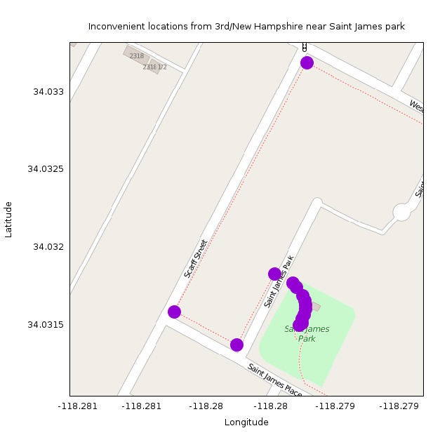
These all appear in an improperly-mapped group of sidewalks around Saint James park: http://www.openstreetmap.org/#map=18/34.03173/-118.27892.
Here the sidewalks appear as separate ways that don't connect with the roads they abut. So according to the data, connecting to the network of sidewalks can only happen in one location, making these appear less convenient than they actually are. (I think these should be removed from OSM, but it looks like the OSM committee people think that mapping sidewalks as separate ways is acceptable. OK; it'll be fixed eventually in some way).
The next cluster of data is about 6km away as the crow flies (source):
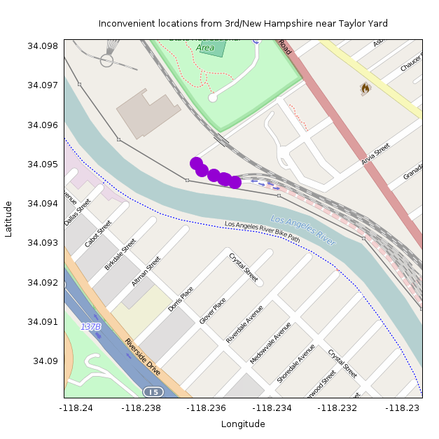
These are all at the road connecting to the Metrolink maintenance facility at Taylor Yard: http://www.openstreetmap.org/#map=17/34.09371/-118.23463. This makes sense! This location is on the other side of the LA river from Koreatown, so getting here requires a lengthy detour to the nearest bikeable bridge. The nearest one (Riverside Drive) is 2.5km by road away, but this is in the opposite direction from Koreatown. The nearest one in the other direction is Fletcher Drive, 3.8km by road.
So the least convenient point from New Hampshire / 3rd is at lat/lon 34.094849,-118.236145. This location is 10.3km away by road, but only 6.0km as the crow flies, for an inconvenience coefficient of 0.72.