In 1920, after a decade of progress, Ben Blow, the head of the Good Roads Bureau of the California State Automobile Association, set out to write the first history of the construction of California’s road system. A marvel of politics, engineering, and finance, the planned system was compared in scale and in ambition to the construction of the Panama Canal. For the frontispiece of his definitive account, Blow chose an evocative image of an open-top car traveling through a narrow gap among the great redwoods of Humboldt County. “In the amazing Humboldt Redwoods,” the caption read. “To be paved with concrete.”
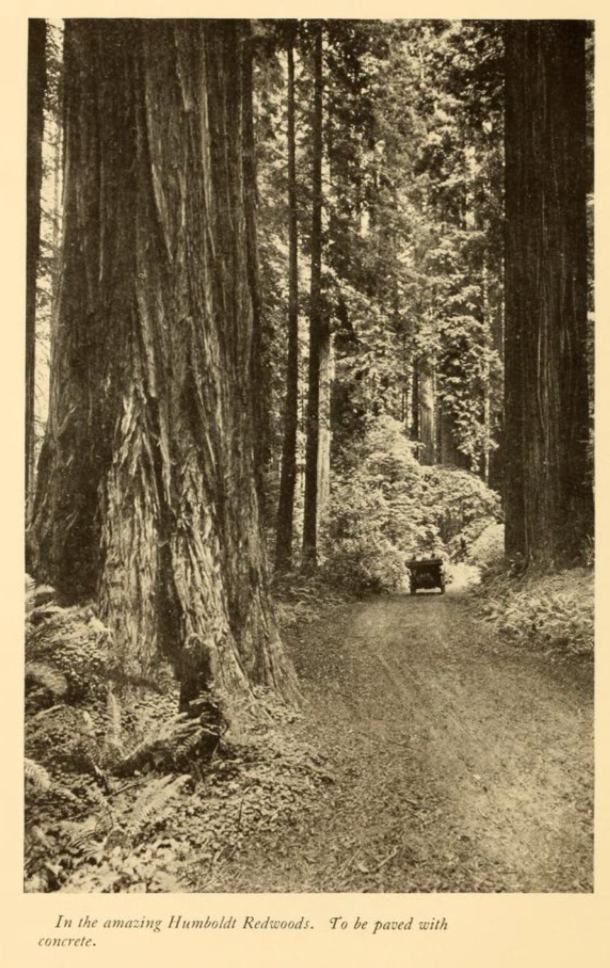
The car is small and the redwoods are massive. The photo has an element of Ansel Adams – extreme contrast and strong geometry that guides the eye toward the automobile, bathed in sunlight, the top down, trundling along a forested path. Ferns stand in the foreground, almost primordial, and the viewer has the sense of explorers venturing into a forest with roots in deep time. The trees in the picture were probably a thousand years old, already ancient when California was still Nueva España. And what the photographer saw, what the caption writer’s mind reached for, was an absence. A road not yet built. The forest was imagined as subordinate to the infrastructure that would make it legible and accessible.
The caption characterized a way of seeing the world, a world-view, which we still inhabit.
• • •
Eight years before Blow’s book, California’s voters had approved an eighteen-million-dollar bond (roughly six hundred million dollars in today’s money) to finance a system of state highways connecting the entire territory. The state founded a Highway Commission to survey and manage the construction of the system. Three men, appointed by the governor, represented virtually the whole coalition behind the project: Charles Blaney, a Progressive Republican from a Chicago real estate background who had founded a bank in Santa Clara County. Burton Towne, the director of the California State Automobile Association and a wine producer. Newell Darlington, a civil engineer from Los Angeles who sat on that city’s Board of Public Utilities. Real estate, agriculture, automobiles, engineering. Bankers, builders, boosters.
Later Blaney would recount how they began. The Commissioners set out in a car to survey possible routes. “We were kicked off mountain roads by mules,” he wrote, “we were stuck in river fords, and we slid around dangerous mountain grades; we broke our windshield and punched holes in the bottom of our gasoline tank on the rocks on the desert.” After covering the trunk lines and laterals of California from Oregon to Mexico, they went back to Sacramento and drew the state highway routes on a big map of the state.
That big map was the beginning of everything that followed. It was a declaration that the territory of California, a state larger than Great Britain and Ireland combined but with one-twentieth the population, would be comprehensible from above and traversable by car. The Commission’s own publication, the California Highway Bulletin, put it in unabashedly imperial terms: the automobile traveler would “surmount that old barrier of Bailey’s Hill, pass Mount Shasta on the north, and leaving the Great Valley in the south, take a panoramic road over the mountains into Los Angeles and roll into San Diego without having shifted gears once from Oregon to Mexico.” The project was to bring, as the Bulletin put it, “city streets to country places.” The aim was not to make the city pastoral, but to export the city’s cartesian logic to the countryside.
The tool they used to make this vision feel inevitable was cartography.
• • •
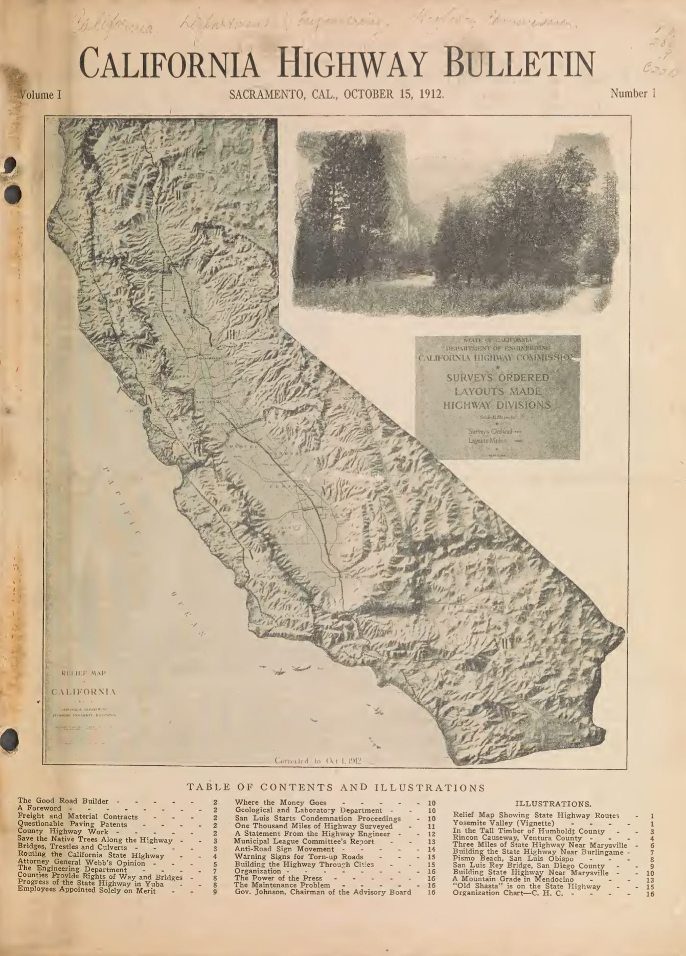
The California Highway Bulletin was published from 1912 for more than fifty years. It circulated about four thousand copies a month to every county supervisor, every newspaper editor, every highway contractor, and every automobile association in the state, nationally, and, it claimed, in fourteen foreign countries. The masthead bore an open invitation for newspapers to reprint anything they found inside. Its editor was a former newspaperman. Its front cover was typically an evocative photograph of a California highway. Its back cover carried a map of the whole state showing the progress of road construction.
Taken as a sequence these maps show something more than engineering progress. They show a systematic program of visual erasure: the step-by-step removal of everything in California that was not a road.
The first issue, October 1912, featured a hill-shaded relief map – the kind that gives the impression of an aerial view, a god’s-eye perspective, every ridgeline and valley rendered in dramatic shadow. It is a beautiful object. It is also largely speculative. Much of California had not yet been topographically surveyed at any useful scale; the U.S. Geological Survey had mapped only a fraction of the state, and whole swathes of the southeast, center, and northwest of the state had no coverage at all. The hill-shade performed mastery over a landscape the Commission barely knew. It made the terrain look conquered before a single road had been laid. Two main trunks were marked: one up the Central Valley, one along the coast. There were no markings for existing roads – only roads to come.
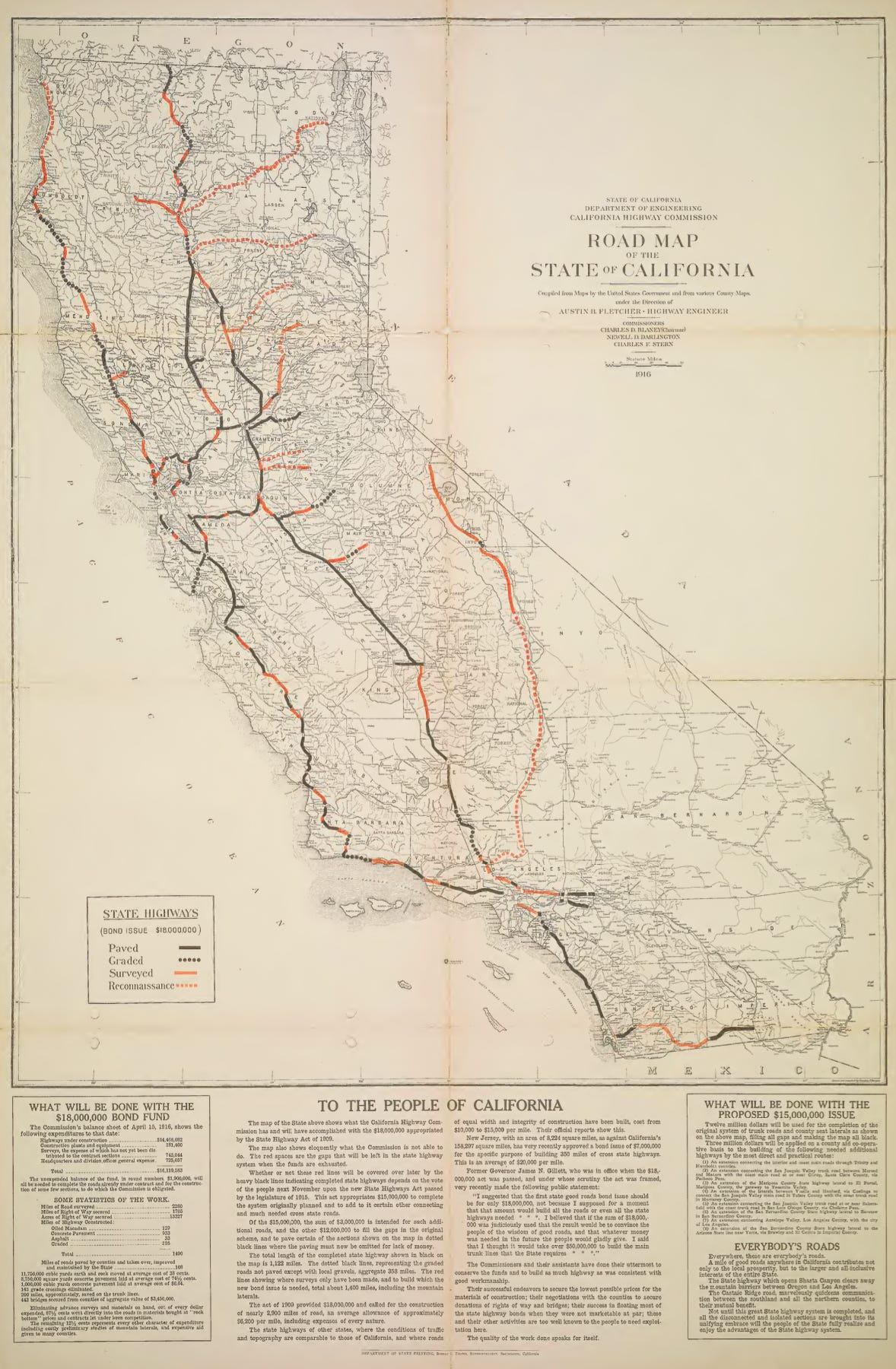
By 1916, the relief shading was gone. A fold-out map showed highways in thick black and rust-red lines against a topographically blank background. Rivers and railroads remained – the highway system’s natural competitors – but every mountain, every incline, every hard-rock pass had vanished. On the old map, you could see why building a road through the Sierra Nevada would be brutal. On the new one, the state appeared as a smooth, featureless plane waiting to be inscribed. And in bold, all-caps type, the map addressed itself directly “TO THE PEOPLE OF CALIFORNIA,” informing them that whether the unfinished red lines would become solid black ones “depends on the vote of the people next November.” The transformation of the state was made equivalent to the transformation of the map – a line solid, a gap closed, as easy as a pen stroke. Or a tick on a ballot paper.
The same issue, a few pages away from this map, described the reality behind the pen stroke. State prisoners – “4,000 men, outcasts, hopeless, a financial and social burden” – were building roads through the mountains the map had erased. One hundred and twenty-five men had worked through a winter of seventy inches of rain and snow in northern Mendocino, every day but Sunday. The map made roadbuilding look like draftsmanship. The text described coerced labor in conditions the topography, had it still been on the map, would have explained.
By 1924, the rivers were gone too. Not a single waterway appeared on the state map except the Colorado, and only because it formed the state border. The coastline, once rendered with topographic shading, was reduced to an anachronistic visual technique called water-lining, decorative ripples suggesting ocean without conveying any geographic information. California’s eight Channel Islands had vanished. Every bay and point and channel label was stripped away. The state that had been connected internally and to the rest of the world for centuries by ocean-faring ships was now depicted as a territory connected exclusively by asphalt.
By the 1930s, the maps had become circuit diagrams – abstract networks of lines connecting named nodes, closer in visual logic to Harry Beck’s London Underground map (which the California version actually predates by seven years) than to anything resembling a landscape. The state floated in white space. The road network was the only thing on it.
Four maps, two decades: each one removed a specific category of reality – topography, rivers, coastline, landscape itself – that was inconvenient to the project. Each removal made the road system look less like a political choice and more like the natural order of California. By the time the sequence was complete, there was nothing left to see except roads, which is of course Ben Blow saw when he stood among the redwoods.
• • •
By the 1950s, maps in the Bulletin became less speculative and more descriptive. The whole-state map appeared less frequently on the back cover, replaced with photographs of gleaming new freeway interchanges. This change reflects the state’s success in molding California in the image of its early map. The map was no longer a politically potent image to aspire toward. It was concrete reality. The ideology had succeeded so completely it had become invisible – not something you believed in, just something you drove on.
It’s a minor footnote, but an irony worth noting: Humboldt County, where Blow’s photograph was taken, was named for Alexander von Humboldt, arguably the first modern geographer and the man more responsible than any other for introducing to the Western public the concept of an interconnected natural world – a worldview about the relationship between all living things. A century later, a man stood in Humboldt’s county, among Humboldt’s ecosystems, and saw missing asphalt.
• • •
I think about that photograph often, because I spend a lot of time walking. I live in London, where I’ve been making my way around the London Loop – a 240-kilometre path that circles the city along city streets, common paths, towpaths, parish boundaries, and public rights of way, some of them centuries old. Walking these paths is like reading the landscape in cross-section. You pass through layers of inscription – a medieval field boundary visible in a hedge line, a canal towpath from the industrial revolution, a Victorian railway cutting, a dual carriageway roaring with traffic – each one recording a different era’s relationship with the land. The path bends, the slope changes, your perspective shifts subtly: planes arrive and depart over your left shoulder, then, slowly, to your right. Every feature responds to something the terrain is doing: a stile at the edge of a field made wonky by mud, or a pathway carved into a hillside where the grade changes. These are records of human attention – of people moving through a landscape at three miles an hour, slowly enough to read it.
California broke that convention in about forty years. It is impossible to walk from town to town across most of the state in anything except precarity. The landscape no longer takes note of you, nor you of it: the road was designed for a vehicle travelling at seventy miles an hour, and at that speed no one can read the land beyond the broad brush. We come to experience landscape as a kind of abstraction, the realisation of the worldview the Bulletin’s road maps had encouraged its readers to adopt.
I don’t raise this to romanticize England or to pretend those paths survived by accident. They survived because people fought for them legally, through rights-of-way law and the Countryside and Rights of Way Act and centuries of common-law battles over access. That’s a coalition story too, just a different coalition, drawing on a different map, one made by feet rather than by commissioners. But if the paths are an inheritance they are also an infrastructure. Walking them gives you something that no amount of urbanist discourse can: the bodily experience of what it feels like to move through a landscape that was shaped by human attention rather than erased by it.
• • •
We are still living in the world imagined by Ben Blow’s photo, and what’s ahead seems in the same spirit - we yearn to go mainly where roads will take us. The most ambitious transportation idea in America is teaching a robot to navigate the road network that Charles Blaney sketched, a revolution of a kind but not one that changes where we go, only how. So the autonomous vehicle is not a break from the Bulletin’s image of California but rather its logical perfection, removing the last remaining variable from a system that has made the road the most legible feature of the landscape. Far from escaping the map, we are trapped within it.
What would it mean to draw a different one? I’m not sure I know. But I think the first step is also the simplest and the most radical: to move slowly enough to see what the old map erased. To walk somewhere that was designed for cars and feel it in your body: stroads with no sidewalks, overpasses with no crossings, landscapes indifferent or hostile to your presence. There’s a point in suffering, following someone else’s map: until you do, it’s hard to appreciate what the California Highway Commission accomplished.
There’s a reward for your suffering: a rescaling of your sense of place to three miles an hour, where the world becomes massive and magnificent again, where you feel the rising path in your heart and legs, where your skin burns in the sun and soaks in a rainstorm, where the terrain has a logic you must follow rather than conquer. Each of us has the capacity to see and to make the world this way, moving across the earth at the speed of close attention. The question is whether we have the ambition to seek it out or whether we’ll keep standing in the redwoods, seeing concrete.