A new map of medieval London
londonist.substack.comHere's the direct links to the digital maps:
https://www.layersoflondon.org/map/overlays/medieval-london-...
https://www.layersoflondon.org/map/overlays/tudor-map-1520
You have to click the checkbox "Use this overlay" to view them.
Looking at the Tudor map, one thing that really stands out is how many abbeys and monasteries there were (shown in pink), and how much of London was taken up by them.
Yes, not surprising that Henry VIII found the idea of dissolving them and taking all their stuff so attractive :)
https://en.wikipedia.org/wiki/Dissolution_of_the_monasteries
Those abbeys and monasteries would've (as part of their endowments) owned large chunks of the agricultural land outside the city as well. I wonder what a modern map, showing all land parcels owned or controlled by an entity with a City address, might look like?
Fun fact: Trinity College of the University of Cambridge has a 999-year lease on the land that the O2 Arena sits on [1][2].
[1]: https://www.theguardian.com/education/2018/may/29/oxford-and...
[2]: https://www.theguardian.com/business/2009/oct/09/trinity-col...
Not entirely the same but related: https://whoownsengland.org/2017/04/17/the-thirty-landowners-...
Well at the time you were looked at differently if you didn't show up at the mass. For a comparable neighborhood size they were much more easily filled at the time they are currently.
I love that we're getting digital maps for earlier eras. What stories are set in XIII or XVI London that these might help clarify?
A little while ago I was reading about Galois' death, and it's surprising how much* one can find online: maps taken near 1832 showing both that he didn't have to go far from the Latin Quarter to meet someone in a meadow at dawn, nor did the farmer who eventually brought him to the hospital (time recorded, ~9h30) have to travel far, either. One could probably even use a sunrise calculator to take the date and figure out an upper bound on how long he had been lying in the field.
(this upper bound should be reasonably tight: the point of duelling at dawn is to have it done with before the farmers get to their fields)
We're only missing the chat logs between ViveLaRépublique and Stephanie15 that might explain what he was doing out there in the first place...
* the coroner's report not only contains what we would consider relevant detail about abdominal trauma, but also contains a detailed examination of his brain and skull structure?
Addendum: too soon?from: ViveLaRépublique @EvistePoly^5 #magicbulletcatchallenge from: Stephanie15 @ViveLaRépublique oopsFAIL delete ur account
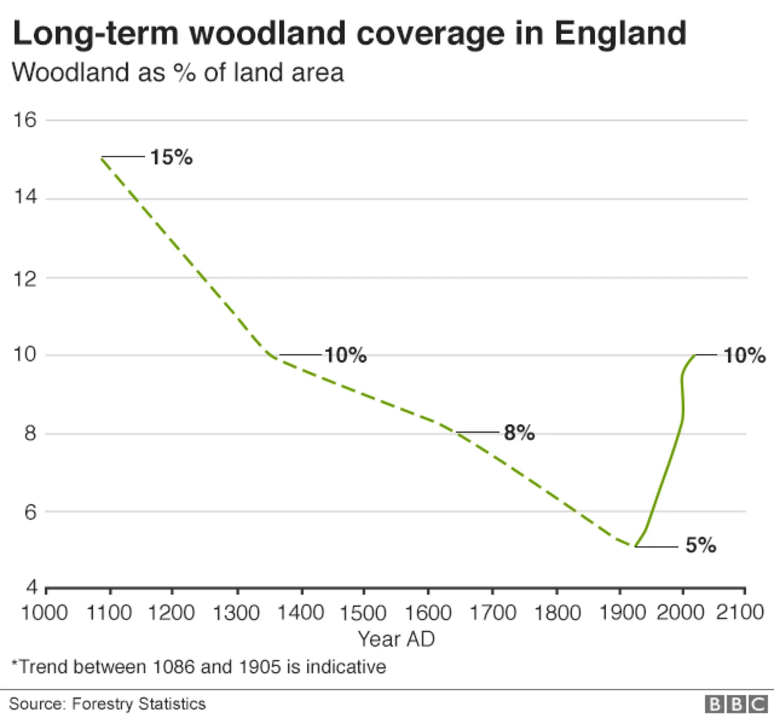
The main feeling I have when seeing maps like this is how incredibly small the city was compared to the present day, and how much more open natural space there must have been across the country. The UK is a very densely populated country - 277 people per km² compared to the overall European average of 72 - and I can't help hankering after a time when nature would have been much more bountiful. (That hankering is of course significantly tempered by the lack of hygiene, anaesthetics, antibiotics, cosmopolitanism, etc, etc!)
It's interesting to read War of the Worlds, and the descriptions of walking between the towns and villages that would one day merge to form greater London. There was all this space between them. Now it's one continuous connerbation.
It's hard to get your head around just how different the geography of the UK was even just in the Victorian/Edwardian eras, and how rapidly it's changed.
There's another interesting example of this effect in Nicola Griffith's 'Hild' books [0], which fictionalise the early life of Hilda of Whitby [1] in 7thC Britain. Some of the towns that we now recognise (York, Ipswich) already existed, but a lot of the action concerns conflict between small (but real) kingdoms that no longer exist, and that exploits the 'redcrest war streets', i.e. Roman roads, for fast tactical movement. This is one book where I really had to study the map at the beginning to figure out what was going on, even though it is my own country.
I remember reading a line from William Blake's diary which talked about him walking "over the fields to Lambeth" from his house in Soho.
More rural areas yes, but England has been shaped by human activities for a very long time. Rural areas are not more "natural" (as in free from human influence) than cities.
> Rural areas are not more "natural" (as in free from human influence) than cities.
Yes, we have very little left of the primary forest that predated human colonisation over much of the British Isles. Areas that we now perceive as wild countryside are usually anything but. One example is those moorland uplands which (in Scotland) were the result of enforced clearances [0] between 1750 and 1850 and which are now often optimised for grouse shooting. The New Forest, my closest national park, is essentially William the Conqueror's hunting estate and where land use and ownership been very tightly controlled since then.
For example, it's worth bearing in mind that the population of Roman Londinium was larger than that of London until about the 16th century, and the population of Roman Britain was also considerably larger than during most of the medieval period. Given the timber-dependent, agrarian pre-industrial economy of the Roman era, this meant an enormous amount of forest removal (military forts and structures like Hadrian's Wall alone would have accounted for a lot of this.)
Thus, any notion of a truly natural landscape of forest in the British Isles disappeared since long, long before the immediately pre-industrial era. Likewise applies for much of Europe even. Again, an example: the landscapes of modern Spain, France and Italy, were repeatedly cleared of forests during their history, particularly by the Roman Empire's needs.
Of course, on the other hand, you could also define natural to mean anything allowed to grow without human intervention for X number of centuries, in which case, yes, there have been many truly natural old growth forests in Europe well after Roman times, simply because they regrew during the hundreds of years between the fifth century and later, heavy population growth prior to the disastrous 14th century depopulation stemming from the Black Death and Great European Famine of the early 1300s (thought to have possibly been caused by a massive volcanic eruption somewhere else in the world)
I certainly wasn't contending that current rural areas are more natural (Isabella Tree's book Wilding is really interesting on what "natural" would have meant in the very long term), but if you're talking about the 13th century - which is one of the maps mentioned above and the kind of timescale I was thinking of - then I'd contend those were much more natural compared to now.
It really depends on your definition of "natural". But in the 13th century, all of European land had been managed by humans for millenia [1]. To consider rural England from the 13th century more natural, you would rely on a definition unrelated to untouched land, but that distinguishes "natural" human activity, and, I guess, "modern" activity ?
Anthropic reach extended since then (e.g. compounds tiny enough to get in blood, or scale of activity creating global impact), but when it comes to landscape, we have been the shaping factor for a very long time.
[1]: https://www.researchgate.net/publication/236630316_Open_wood...
True, but these are also medieval farmer’s fields, about as all-natural and organic as possible. They are certainly more natural than a parking lot, and barring very much stone construction would probably rewild within a generation or two.
Edit: The more I think of it the stone construction really is the most unnatural part. Especially the ancient tradition of building those little walls using the stones you cleared in order to plow.
That probably somewhat depends on what you consider "natural".
While I'm not an expert - to my knowledge the land/resources were pretty thoroughly exploited and agricultural productivity wasn't exactly high. You'd have seen a lot of farm fields/pastures stretching across vast areas and things like that. Not that much "wild", unaltered/unworked land.
> and how much more open natural space there must have been across the country.
That depends on the country/area a lot though. UK is a bit of an exception because it's population increased much more than almost anywhere else in Medieval Europe but in much of France and other places some rural areas were possibly more densely populated even back in the 1200s (populations are much more concentrated these days while they were more spread out before the industrial revolution).
Even in England there are probably more forested areas these days than at any point since the 1400s or so.
Also the forests with their ancient (and huge) trees. Britain pretty much got clear-cut in the Industrial Revolution. Those ancient forests must have been a sight to behold.
England was mostly clear cut long before the Industrial Revolution. That was possibly one of the main reasons it happened, there was huge demand for coal because there was little available firewood.
e.g. https://ichef.bbci.co.uk/news/1536/cpsprodpb/144BD/productio...
But today, there's whole lot more greenery in UK than at the bottom of deforestration that happened around ~1955.
But not enormous thousand-year-old ancient trees and the landscapes shaped by them.
If these were chopped, they were for high-order uses like shipbuilding in the time of sail. They are too hard to saw to use as timbering in coal mines (which is assume where most wood has gone during the Industrial Revolution)?
My aunt worked with Mary Lobel on the original Atlas (I inherited her copy) mainly as a "retirement project" - it was fascinating to see the research laid out on her table and the various sources that informed the whole exercise. Things like the details of a court case between neighbours indicated that XYZ street was 1 foot wider at a particular point than previously thought or similar findings. I remember at the time wondering why they couldn't publish just the maps as they were fascinating (with the academic papers that made up the rest of the Atlas). Fortunately, a decade or 2 later that's what they did.
I was walking North through the back streets of the City just a few days ago - from London Bridge to London Wall. It's amazing that so much of my route - zigzagging left and right through various junctions and down alleys - is clearly visible on an 800 year old map. I suspect none of the buildings are the same, but the roads are still there.
That reminds me of the trapezoidal Chrysler Building[1] in NYC, shaped by a plot boundary reflecting the pre-grid Boston Post Road[2] (only 2 weeks NYC-Boston!). The Road elsewheres reflects 1600's colonial improvements to the earlier Pequot Path, and influenced US1 et al.
[1] https://ephemeralnewyork.wordpress.com/tag/chrysler-building... [2] https://en.wikipedia.org/wiki/Boston_Post_Road
I remember reading about an archeological dig in an intersection in the old part of Damascus. They dug down though a few thousand years of accumulated soil and found nothing.
That was by far my favorite part of visiting London, you could really feel and see how much of the city was still as it has been for a thousand years...just the penny rooms are now luxury flats.
There's something about Fridays and weekends at HN that always brings some form of utility for my historical BX (older version of D&D) group. Thanks for posting.
Enormously powerful but also.. enormously confusing and slow to render on a tablet. I think it should all be there but perhaps less could be shown at first? Great to scroll around in but.. laggy
No problems on my an iPad Air m1, seems there is a purpose after all for all the cpu power in tablets…
renders fine on my 4y old android phone
Is this could be linked with the Baroque cycle By Neil Stephenson it would be awesome, I was tying to find fleet ditch and couldn't see it!
So Fleet Street crosses what was the Fleet river, which ran North-South along the boundary of the City
Nice, was getting sick of my old map of medieval London
Now we just need street view.
True; get the cosplayers and ren faire people on it, stat?
I was already happy to have ISS street view: https://www.google.com/maps/space/iss/@29.5602853,-95.085391...
(exercises:
Find the ikon of Gagarin.
Is the speed limit sign accurate?)